The Ho Chi Minh Trail and the South: What It Really Was
Is the Ho Chi Minh Trail a place you can visit near Ho Chi Minh City?
No single site is 'the' Ho Chi Minh Trail. It was a dispersed logistics network of roads, paths and river routes stretching across several regions, not a location with a gate and a ticket booth. The Cu Chi Tunnels, which are visitable, were a separate underground network built and used for different purposes, though the two systems intersected in the war effort.
A Name, Not a Place You Can Walk Into
Ask a handful of visitors to Ho Chi Minh City what the Ho Chi Minh Trail was, and most will point vaguely toward the tunnels at Cu Chi. It’s an understandable mix-up. Both belong to the same war, both involved hiding and moving people and supplies out of sight, and both get folded into the same rushed paragraph in guidebooks and tour scripts. But they were not the same thing, and understanding the difference actually makes a visit to southern Vietnam’s war-history sites more interesting, not less.
The Ho Chi Minh Trail was never a single road, tunnel or fortified position. It was a name given, largely after the fact, to an extensive and constantly shifting network of paths, tracks, river crossings and supply points used to move personnel and materiel from the north toward the battlefields of the south. It grew, branched, rerouted around bombing and monsoon damage, and existed less as infrastructure in the modern sense than as a living, adaptive system of movement through difficult terrain. There is no gate to walk through, no single preserved stretch you can book a ticket for, because there was no single stretch to begin with.
This matters for travelers because so much of what’s marketed around Ho Chi Minh City leans on the trail’s name for atmosphere, while what’s actually being shown is something else: the Cu Chi Tunnels, the War Remnants Museum, the Reunification Palace, sites connected to the war but not physically part of the trail itself. None of that makes those sites less worth visiting. It just means the trail deserves to be understood on its own terms rather than as a synonym for whatever war-era site happens to be nearby.
A Network, Not a Line on a Map
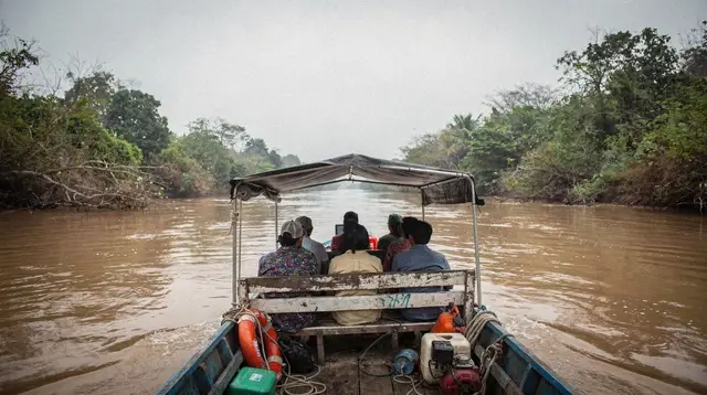
The easiest way to picture the trail correctly is to stop imagining a line and start imagining a web. Rather than one continuous corridor, it was a shifting mesh of routes running through mountainous and forested terrain well outside the areas this site covers, threading through neighboring countries before smaller branches fanned out toward different fronts in the south. Sections that became exposed or heavily targeted were abandoned in favor of new paths cut through the terrain; river crossings and mountain passes were adapted to what was possible in a given season rather than fixed once and left alone.
That adaptability was the entire point. A distributed system with many alternate routes is far harder to cut off than a single road, and the trail’s planners and the people who built and maintained it treated it accordingly: less as a piece of engineering to be finished, more as a capability to be maintained under pressure. Supplies moved by porters, by bicycle, by truck where terrain allowed, and by river craft where waterways offered a faster or safer option. Way stations, rest points and storage depots were spread along the network rather than concentrated at a single hub, which is precisely why no single visitor site can claim to represent “the trail” as a whole.
This is also why the trail resists the kind of clean statistic that tour scripts like to reach for. It changed too much, over too long a period, across too much terrain, for any single figure to describe it honestly. The more useful thing to understand is its function: a logistics system built to keep supplies and reinforcements flowing south despite sustained efforts to interrupt it.
Why Cu Chi Is Something Else Entirely
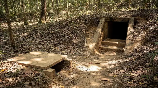
The Cu Chi Tunnels, by contrast, were a localized and highly specific underground network, dug into the ground of what is now a district of Ho Chi Minh City itself, close enough to the city that it’s a manageable day trip rather than a multi-day expedition.
Their purpose was different too: shelter from bombardment, concealed movement between positions, storage of supplies and weapons close to the area of operation, and in some places, functioning almost as an underground village with kitchens, meeting rooms and medical spaces built into the tunnel system. Read more on how the Cu Chi tunnel network worked if you want the mechanics behind what tour guides show visitors on-site.
Cu Chi’s tunnels served the immediate area around Saigon; the trail served the entire war effort across a far larger stretch of the country and beyond. Cu Chi was fixed in place, dug into specific ground that can still be visited today at either of its two preserved sites; the trail moved, rerouted and adapted as conditions changed, leaving no single “site” behind in the same sense. If you’re deciding between visiting Ben Duoc or Ben Dinh, or weighing a half-day against a full-day Cu Chi visit, you’re making decisions about the tunnels specifically, not about the trail.
It’s worth being direct about this because the confusion runs in a specific, avoidable direction: travelers often assume that because Cu Chi is close to Ho Chi Minh City and involves tunnels, it must be a fragment of the trail they’ve heard about. It isn’t. The two systems existed for different reasons, in different places, at different scales, even though both were shaped by the same broader conflict and by the same underlying need to move and hide from a technologically superior adversary.
How the South Fits Into the Larger Picture
Southern Vietnam, and Ho Chi Minh City in particular, sat at the receiving end of the logistics effort the trail represented, without hosting its principal corridors. The city, then Saigon, was the political and military center that supply lines further north were ultimately working to reach or to support fighting near. That positioning is part of why so many of the region’s war-history sites cluster around the city rather than along any trail route: the War Remnants Museum and the Reunification Palace tell the story of the war’s outcome and its human cost from the vantage point of where it concluded, not from along the supply routes that fed it.
Further out, the countryside around Ho Chi Minh City held its own separate wartime infrastructure. The tunnels at Cu Chi are the best-known example, but the wider area northwest of the city, including districts closer to Tay Ninh, saw its own patterns of movement, concealment and conflict distinct from the trail proper. A Cu Chi Tunnels and Cao Dai Temple day trip combines a war-history stop with a look at the region’s distinctive religious history, and it’s worth going into that pairing understanding that you’re visiting two different threads of the area’s story, one military, one religious, that happen to sit along the same road.
The Mekong Delta further south had its own wartime experience too, shaped by rivers and waterways rather than jungle trails, with river routes serving purposes not unlike what roads and paths did elsewhere. None of this was the Ho Chi Minh Trail either, but it’s part of the same broader pattern: the south absorbed and adapted to the pressures of a long conflict in ways that varied enormously by geography, and flattening all of it into one trail name erases exactly what makes the region’s war history worth learning about in detail.
Getting the Story Straight When You Book a Tour
Because tour marketing leans so heavily on evocative names, it’s common to see a Cu Chi Tunnels tour described with language that borrows the trail’s reputation. That’s a marketing shortcut, not a factual claim, and it’s worth reading past. A guide worth booking will be able to explain, on request, what you’re actually standing in when you’re at Cu Chi, and how it relates to, and differs from, the broader trail network that ran through other terrain entirely.
If your goal is a tangible, on-the-ground sense of the era, the most direct routes are the Cu Chi Tunnels themselves and the war-history sites within Ho Chi Minh City. A standard Cu Chi Tunnels tour from Ho Chi Minh City covers the tunnel system with a guide who can walk you through its specific history, separate from the trail. Travelers short on time sometimes prefer the afternoon Cu Chi Tunnels tour, which fits the same site into half a day.
For a longer view that connects the war-history stop to the region’s other landscapes, the multi-day Cu Chi and Mekong Delta tour pairs tunnel history with delta life, making the contrast between the two histories easier to feel rather than just explain. And if the delta side interests you more than another pass through war sites, a Mekong Delta day trip by bus gives you that region on its own terms.
Whichever combination you choose, pairing a Cu Chi visit with time at the War Remnants Museum or a Saigon war sites walking tour rounds out the picture considerably. Those stops address the war’s broader history and its aftermath directly, in a way that helps place the trail’s role in context even though none of the sites sit on its former routes. For visitors who want a guide with deeper, lived context, several operators run tours led by veterans, which can add a dimension no script fully captures.
Tay Ninh: Close on the Map, Separate in the Story
One detail trips up even travelers who have already sorted out the difference between the trail and the tunnels: Cu Chi and Tay Ninh are often booked as a single day trip, but they belong to two different administrative and historical stories. Cu Chi is a district of Ho Chi Minh City itself. Tay Ninh is not part of the city at all; it’s a separate province further northwest, and the Cao Dai Holy See that draws most visitors there is the seat of Caodaism, a distinctly southern Vietnamese religion with no connection to the war-era trail network. The two stops sit on the same road and get combined for convenience, not because they share a history.
The Holy See holds a ceremony around midday, which is the reason tours built around it are timed the way they are: arrive at Cu Chi first, then continue on to Tay Ninh in time to see the service rather than an empty hall. Our Cao Dai Temple, Tay Ninh guide covers what the ceremony involves and how to behave respectfully as a visitor; a combined Cu Chi Tunnels and Cao Dai Temple day trip is the standard way operators package the two.
Tay Ninh province also holds Ba Den, the Black Virgin Mountain, the highest point in the south, reachable on foot or by cable car. Like the Holy See, it has its own separate identity: a pilgrimage site and a viewpoint, not a war-history stop, and not connected to the Ho Chi Minh Trail beyond sharing the same general stretch of countryside. Some tours pair a Tay Ninh and Black Virgin Mountain day trip instead of the Cao Dai-and-Cu-Chi combination, depending on how much time is available and which side of the region’s story a traveler wants more of. Either way, treating Cu Chi, the Holy See and Ba Den as three distinct threads, sharing a road but not a history, avoids the same flattening that confuses the trail with the tunnels in the first place.
Building This Into a Longer Trip South
Travelers with more than a single day to give to the region’s war history and its surrounding geography have room to separate the threads properly rather than compressing them into one rushed itinerary. A dedicated one-day Cu Chi Tunnels trip from Saigon keeps the tunnel visit focused, without folding in the Tay Ninh side trip or trying to also cover the Mekong Delta in the same afternoon. For a broader survey that places the war-history sites alongside the Mekong Delta and other southern landscapes, a longer route such as the seven-day south Vietnam grand loop or the more compact three-day Saigon, Cu Chi and Mekong classic gives each region enough space to be understood on its own terms.
For travelers who’d rather have someone else sequence all of this, a multi-day option like the 7-day tour of southern Vietnam or the 3-day exploration of the south strings the war-history sites, Tay Ninh and the delta together in a planned order, which removes the guesswork of deciding what belongs with what. That kind of structure is often the easiest way to actually absorb the distinctions this page has been making: the trail as an idea, Cu Chi as a specific place, and Tay Ninh as a separate story again, each one clearer once it isn’t being rushed through in the same half-day as the others.
Anyone building their own schedule rather than booking a packaged multi-day tour should also read how many days to budget for southern Vietnam before locking in a route, since the war-history sites, Tay Ninh and the delta each deserve enough time to register as distinct rather than blurring into a single “war and countryside” day.
The Short Version to Keep in Mind
The Ho Chi Minh Trail was a network for moving people and supplies across a wide swath of terrain over a long period, constantly adapting to pressure and changing conditions. It was not a fixed place, and it does not correspond to any single site near Ho Chi Minh City. The Cu Chi Tunnels, by contrast, are a specific, visitable, localized underground network built for different purposes, close enough to the city to visit in a day.
Treat the two as related but separate threads of the same larger history: understanding that distinction is what turns a Cu Chi Tunnels tour from a vague gesture at “the war” into a genuinely clearer picture of how the south experienced it, and it makes stops like the Reunification Palace’s history land with more weight once the geography of the conflict actually makes sense.
War History: Cu Chi Tunnels and the War Remnants Museum
Verified deep-linked GetYourGuide tours. Book through these links and we earn a small commission at no cost to you.
GetYourGuide does not provide a product photo for this activity — the image shows the meeting point, photographed by us.